-
 A global pandemic has made the past year-and-a-half stressful to say the least, and even Mother Nature screams sometimes. “This is the worst tornado event we’ve ever been through,” Kentucky
 -
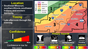
 National Weather Service meteorologists are projecting a 10% risk of tornadic activity and a 30% chance of winds over 58 miles per hour as a line of storms sweeps across southern Missouri, southern Illinois and western Kentucky.
 -
 The National Weather Service is calling for severe thunderstorms Monday evening in western Kentucky and southern Illinois. NWS Paducah Lead Forecaster Dan…
 -
 Lead forecasters at the National Weather Service of Paducah said western Kentucky should expect severe thunderstorms, damaging winds and the potential for…
 -
 The National Weather Service (NWS) of Paducah aims to promote severe weather safety with a week-long educational campaign. The Spring Severe Weather…
 -
 Heavy rainfall across western Kentucky flooded low-lying roads and other areas Sunday leading to road and property damage throughout the region. Residents…
 -
 2nd Update: The National Weather Service in Paducah said Monday afternoon that the damage survey team has found preliminary EF-1 tornado damage across…
 -
 Update: The National Weather Service in Paducah survey teams say the tornado in Carlile, Ballard and McCracken Counties Thursday morning was an EF-2, with…
 -
 Update: The National Weather Service confirmed this was an EF-1 tornado with estimated peak winds around 110 miles per hour. Read their assessment. Severe…
 -
 UPDATE 4:09 p.m.: National Weather Service Forecasters have reduced their confidence in the timing of the storm. The region remains in at an "enhanced" to…

© 2025
News and Music Discovery
Play Live Radio
Next Up:
0:00
0:00
Available On Air Stations


