

Four Tennesseans have died in the winter storm, and officials are bracing for days of recovery from widespread power outages and recovery efforts slowed by ice and downed trees. Here’s the latest from WPLN, updated at 8 a.m. Monday.
State officials reported storm fatalities in Crockett, Dyer and Obion counties in West Tennessee, and in Haywood County in East Tennessee.
At the peak Sunday, more than 300,000 people were still without power after sunset. As of 8 a.m. Monday, there were 250,000 outages in Tennessee and about 150,000 in Davidson County.
Outages set a record for NES in Davidson County.
Brent Baker with NES said the utility is scrambling to respond, but that it was a complicated situation with so many lines down and the number of outages climbing.
“We are letting people know this is going to be a prolonged event. Likely multiple days,” he said Sunday afternoon.
NES reported more than 70 broken poles.
Drinking water facilities are also impacted — but still providing water — in nine counties.
In addition to the power grid and roads, this winter storm is impacting communications infrastructure.
The Tennessee Emergency Management Agency says some areas of the state have reduced cellular service due to power loss and ice damage. When regular calls are not possible, cell phones can still be used to call 911. But officials emphasize that number is only for life-threatening emergencies.
Warming centers
In a rare move, Metro is opening fire stations and most police precincts — not Central or East — as warming centers. But if you need to leave your home to get warm, officials are urging caution. Warmth is available around the clock, but most of the centers do not have overnight accommodations.
The Nashville Fairgrounds is one exception, says Metro Police Chief John Drake.
“The fairgrounds would probably be the first location that you can go because we’ve got cots set up and we’ve got Red Cross members there,” he said during a Sunday briefing. “We’ll have the ability to feed.”
Two Metro Parks Community Centers — Southeast in Antioch and Madison — will also have cots.
Statewide, there are more than 100 warming centers open, with varying local hours and availability.
‘Impossible’ and dangerous travel
A federal disaster has been declared for all 95 counties. Gov. Bill Lee said Sunday that the declaration will support winter storm operations and recovery.
Nashville International Airport’s air traffic control tower reopened Monday morning, and the airfield is operational again. But the winter storm is affecting many flights.
Downed trees have blocked roads in many areas, and the National Weather Service describes travel as “dangerous to impossible.” Much of the pretreatment, like brine, that was applied to roads ahead of this winter storm has been washed away.
- In Nashville, WeGo suspended service at 7:45 a.m., citing the weather disrupting communication infrastructure that connects with buses. Limited hours were later restored for part of the day.
- The Tennessee Department of Transportation reported more than 800 incidents in roughly the first 24 hours of the storm.
- The Tennessee Highway Patrol reported 36 crashes with injuries, more than 100 vehicles damaged and more than 150 obstructed roads — many from fallen trees. A few dozen additional vehicles have been abandoned.
Nashville Department of Transportation Director Phillip Jones warned that Monday’s road conditions will likely be even worse. Ice melting and then re-freezing creates the dreaded “black ice.”
“It’s a little more treacherous than what we had earlier, just because you can’t see it,” he said. “It looks like the road may be clear, but it’ll be a solid sheet of ice.”
Foreboding forecast
Meteorologists increased the expected ice accumulations for the state, and as of Sunday morning another half-inch of ice was still expected across a long swath of Middle Tennessee — including in Nashville.
The forecast for the week is foreboding. The weather service continues to warn of prolonged impacts, with temperatures likely to remain below freezing into next weekend, with few brief exceptions. For people without power, the temperatures will be dangerously cold.
The depth of the freeze will be at its worst overnight Monday into Tuesday, with the temperature in the single digits.
NWS meteorologist Faith Borden says a big concern is “flash freezing.”
“Any moisture will immediately freeze on the surface,” she said.
Another concern: Wind. Gusts could reach 25 mph on Monday. That usually wouldn’t be an issue — it’s really just a strong breeze. But it means even more pressure on trees and power lines.
Statewide impacts
East Tennessee is under a cold weather advisory until Tuesday. Ongoing heavy rain is forecasted to freeze over as temperatures drop to as low as single digits Monday. That means roads that were already pretreated may see some ice patches.
“We are dependent on those road crews to make sure they’re getting out there and seeing what roads are drying up on their own and what needs to be treated again as we have this extended freeze for the start of the new week,” said Heather Haley, a meteorologist with WUOT in Knoxville.
Warming centers in Knoxville are also preparing for an uptick in people seeking shelter as temperatures drop. Four centers across the city are scheduled to open tonight, including the nonprofit seasonal shelter ReLAUNCH in downtown.
ReLAUNCH was one of the few shelters that were open at the start of the storm Saturday due to anticipated road conditions. The nonprofit reached its capacity quickly, prompting officials to more than double that number to 130 people. Executive Director Linda Conaway said she’s prepared to serve at least an additional 200 people during the extended freeze.
“We haven’t had this long stretch of cold yet this season,” she said. “Everybody’s going to need the opportunity to reset and reinforce … because a lot of folks just won’t be prepared for this length of cold.”
So far, several hundreds of people have sought shelter in downtown Knoxville during the ice storm.
This post was last updated at 8:02 a.m. Monday.
Reported earlier on Saturday
The wait is over. A major winter storm that’s sweeping through the U.S. mid-section has entered Middle Tennessee and Southern Kentucky.
The system arrived Saturday morning, a bit later than forecast, but bringing the wintry mix of snow, sleet and ice as expected.
The entire state of Tennessee is under an emergency declaration issued by Gov. Bill Lee. State and local emergency crews are working to manage conditions that might impact travel, electrical power and general safety. Multiple school and church closings and event cancellations or delays are underway.
By noon Saturday, more than 300 flights had been cancelled at Nashville International Airport.
 Tony Gonzalez WPLN News
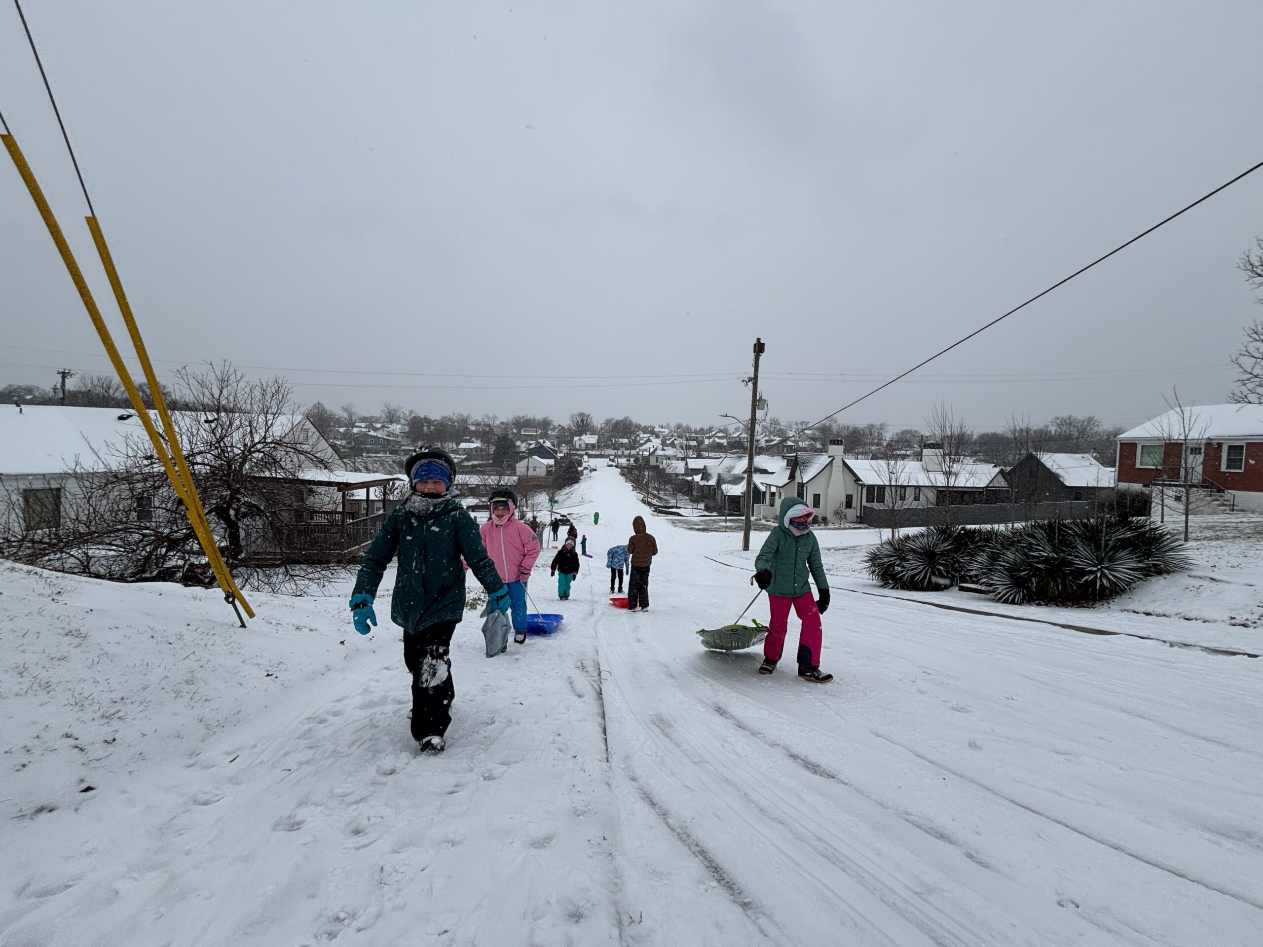
Kids sled on Russell Street in East Nashville.
Snowfall in the Nashville area was 2-3 inches by Saturday afternoon. The mid-state is now experiencing a mixture that is more sleet and freezing rain, according to the National Weather Service in Nashville. Forecasters say we are more likely to have ice accumulations overnight into Sunday and extremely cold termperatures, dipping in to the single digits by Monday.
Impacts
The wintry mix is causing dangerous travel conditions. Metro Nashville Police (MNPD) report more than 70 car accidents by 2 p.m. on Saturday. The Tennessee Department of Transportation (TDOT) also reports increasing incidents on roadways and their HELP trucks have been busy assisting motorists. Drivers are advised to get to their destinations as soon as possible because conditions are expected to rapidly decline tonight.
No significant power outages have occurred, but that is likely to change as ice accumulates through the weekend, causing downed trees and branches that can damage power lines. Increasing energy demand can also cause power disruptions.
Preparations and services
For those who need shelter from the dangerous cold, warming centers are available throughout the state. The Tennessee Emergency Management Agency (TEMA) maintains a map of these centers.
The Metro Emergency Overflow Shelter is open and will continue to operate 24 hours on Saturday, January 24th and Sunday, January 25th. The agency will monitor conditions and provide shelter as long as temperatures are below 32 degrees for three consecutive hours.
Metro Social Services has activated its Severe Weather Response, offering emergency meal delivery to homebound residents like seniors and disabled folks before the storm hits.The service will also increase its number of senior house-calls and work with emergency services around the clock to help those affected by the storm.
Officials recommend that people take precautions such as dressing warmly, bringing pets indoors and keeping an eye on the latest forecast.
Nashville Electric Service and Tennessee Valley Authority are prepared for potential power outages.
A Crisis Cleanup Hotline is active to provide free property cleanup assistance related to the winter storm. Requests can made by phone at 844-965-1386. The service is provided by volunteer organizations.
Cancellations and delays
Multiple school districts, colleges and universities have announced closures, delays or changes to in-person participation. Metro Nashville Public Schools and all districts in the counties contiguous to Davidson will be closed Monday, January 26 and Tuesday, January 27.
Middle Tennessee State and Tennessee State universities will have remote learning on Monday.
Copyright 2026 WPLN News


